gary-kerkin.ip-ddns.com: the ruminations of an octogenarian
There is a tendency among modern journalists to write about the events they are reporting in hyperbolic terms: “the greatest ever …”; “the worst ever …”, “the most dangerous …”; “the most savage …”.
I listened to a talk recently by a retired journalist, a sometime Reuters correspondent, Subeditor, and Editor, who expressed his disquiet about the lack of historical perspective among younger journalists, a situation I often refer to as having a “lack of racial memory”. The situation became apparent in New Zealand a few years ago when many old(er) journalists retired and/or “were let go”. The accumulated memories of those experts were suddenly missing from our news media and it has never recovered.
I suspect the reason for this is the way the craft of journalism is being taught now. I think young, enthusiastic, aspiring journalists are not being given a sense of how important history, context, and perspective are in what they try to report.
Of interest to me is the way journalists report the science and events of climate change or what was called “global warming”. By and large I find their language hyperbolic and that they often uncritically report what I can best describe as “propaganda”, breathlessly writing about the “alarming and dangerous” situation the world finds itself in. Droughts are always the worst in history. Floods are the most severe in living memory. Fires are the most extreme ever experienced. All because of climate change! They would do well to leave hyperbole to those with memories that stretch back 50 or more years and who are aware of even earlier history.
Early in 2023, New Zealand experienced severe weather events causing much damage to property and distress to inhabitants. Rain storms caused flooding in West and South Auckland. The Te Tairāwhiti region around Gisborne and the northern and eastern Hawkes Bay regions were badly damaged by the remnants of Tropical Cyclone Gabrielle. The news media at the time attributed these events to climate change quoting a Government Agency which failed to correctly analyse and report the events. Needless to say, the usual hyperbolic language flooded the news reports and a study by an investigative journalist, who possesses a strong sense of that “race memory” I referred to, revealed that the National Institute of Water and Atmospheric Research (NIWA) had little information on historical storms which affected New Zealand regions to greater and lesser extents. NIWA claimed that Cyclone Gabrielle was one of the worst storms to affect New Zealand and the media went further, attributing it to climate change—which NIWA did not refute. Cyclone Gabrielle indeed was one of the larger storms to affect New Zealand but NIWA was unable to say just how seriously because, as journalist Ian Wishart of Investigate Magazine clearly demonstrated in a report, “The Climate of Fear”, (https://ianwishart.com/2023/03/climate-of-fear/), it had no records of many storms reported in the latter half of the 19th Century with recorded minimum sea level pressures (MSLP) lower than that of Cyclone Gabrielle. To justify his using MSLP as a metric for the severity of storms, Wishart cited a paper “Characterizing Continental US Hurricane Risk: Which Intensity Metric Is Best?” (https://doi.org/10.1029/2022JD037030) which suggested that MSLP is a better guide to the strength and destructive power of a storm than is maximum wind velocity.
Some scepticism was expressed about the accuracy of values of MSLP listed by Wishart for severe storms in the second half of the 19th Century but as he pointed out elsewhere the pressures were recorded by Harbour Masters whose jobs included keeping accurate records. By way of examples he listed 19 severe storms (with their MSLP in mm of Mercury) between 1860 and 1874
1. 948, March 1860
2. 951, June 1876
3. 955, Feb 1868
4. 958, June 1889
5. 958, Jan 1884
6. 958, Jan 1939
7. 959, Oct 1868
8. 963, Dec 1871 (Gabrielle in 2023 was also 963)
9. 967, Dec 1871
10. 968, Mar 1871 (Giselle in 1968 was also 968)
11. 970, Dec 1868
12. 975, Jan 1869
13. 978, Sept 1887
14. 980, Feb 1874
15. 982, July 1871 (Bola in 1988 was also 982)
16. 984, July 1875
17. 984, May 1880
18. 985, June 1868
19. 985, Sept 1874
As can be seen from this list several storms were more severe than Gabrielle and, ironically, many were not in the historical records maintained by NIWA. Wishart contenteds that without knowledge of such storms NIWA and the New Zealand media are in no position to be able to analyse and judge the relative severity of Gabrielle, let alone take the liberty of describing its importance in hyperbolic terms. This list also shows that storms of such severity were not unusual in New Zealand. He continued his study into storms in the 20th Century further proving his point.
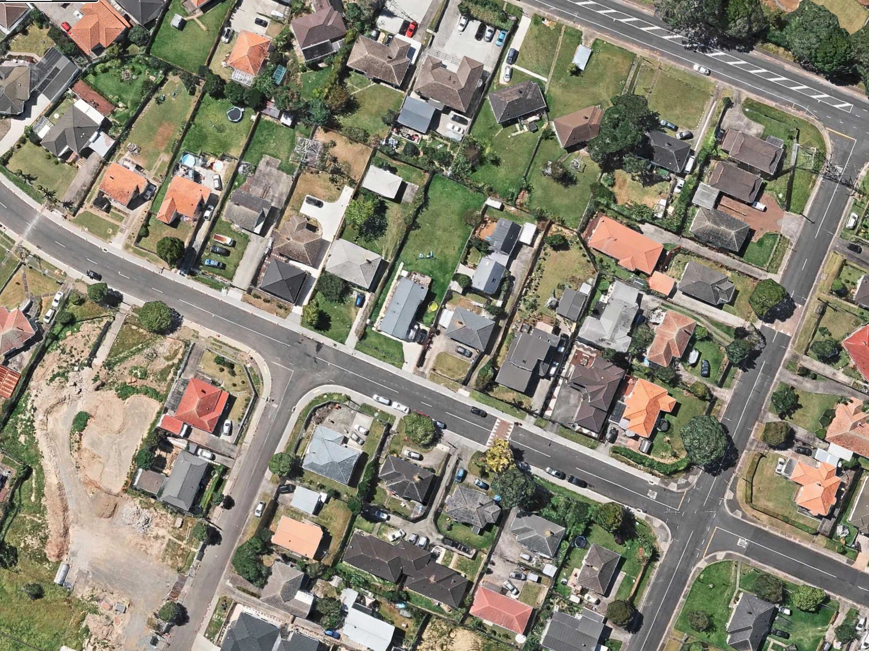
Of just as much importance is the analysis of the damage done in both events and why it occurred. The media attributed the events to climate change even though, as Ian Wishart demonstrated, events such as Cyclone Gabrielle are not unusual. The flooding in Auckland was perhaps unusual but despite the several reasons extended in the media—a climate-change engendered rain event, inadequate drainage infrastructure, poorly chosen development sites—I saw no mention of the change in land use over the century and a half or more Auckland has developed. When Europeans first settled those parts, West and South Auckland could be described as open savannah—light scrub-covered ground which was well drained. It would have experienced few problems in draining the effluent from severe rain events. The situation is very different now. The majority of the area is impermeable—roads, rooves, and pathways meaning that water accumulates as it drains away from rain events and cannot easily escape, possibly having to do so through inadequate drainage infrastructure. My knowledge of some of the areas dates from my early teens more than 70 years ago when I used to ride a bicycle through the regions to visit relatives who lived in a newly developed area in Mt Roskill which, as this picture shows (Apple Maps), has changed since then. While some houses remain on their original allotments
—this was a time when New Zealanders aspired to own a home on a “quarter-acre section”—many properties have since been subdivided and newer dwellings built, increasing the population density and reducing the net area available for drainage of rainwater.
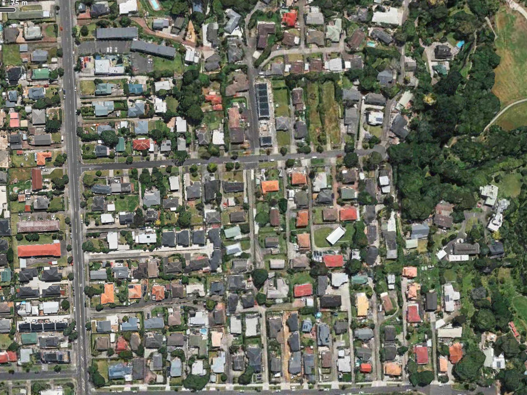
The second photograph, taken further to the west, in the Avondale area of Auckland, shows dense in-fill building, which exacerbates the problem. Housing developments this century are even more dense and I do not find it surprising that land developed in this way cannot cope with the run-off from extreme rain events. To my mind, this change in land use is a more likely explanation for the Auckland flooding of February 2023 than is blaming extreme weather an extreme event caused by climate change—weather events which, as Ian Wishart has shown, are not unusual in New Zealand history.
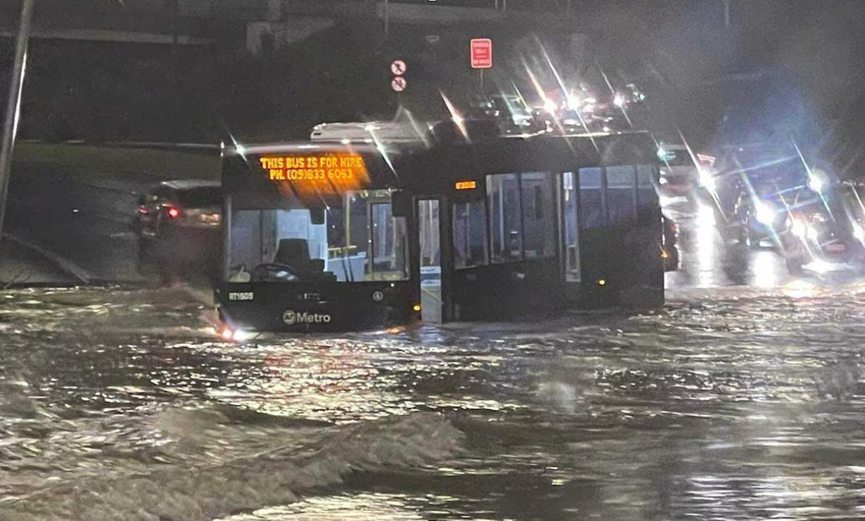
The extent to which the drainage system around Auckland was unable to cope is demonstrated by this photograph of a stranded bus.
Equally significant is the change in land use in the Eastern region of the North Island of New Zealand. The past few decades have seen much grazing and arable hill country planted in pine forests, often as a result of the imposition of carbon taxes and the profitability of exotic forestry. Exotic forests around this region have reached maturity and are being harvested but the process of clear-felling leaves behind detritus known as “slash”. It is this detritus which caused the most damage to the region where the slash was washed downstream fetching up against banks, stop-banks, and bridges causing widespread flooding and damage. Examples of the effect of slash are shown in the following photographs taken from The New Zealand Farmer.
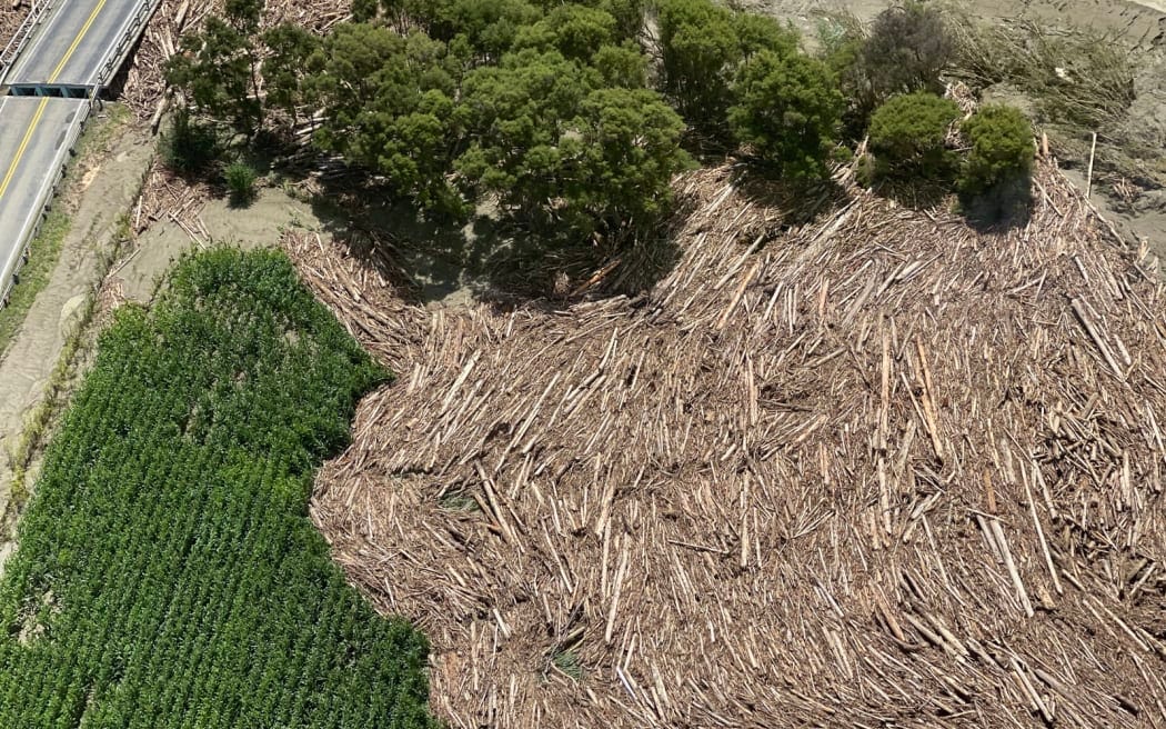
This was slash (https://www.farmersweekly.co.nz/wp-content/uploads/2023/02/Tolaga-Bay-Gabrielle-1-1.jpg) left in Tolaga Bay.
One year on, in February 2024, The Farmers Weekly published this photograph (https://www.farmersweekly.co.nz/wp-content/uploads/2023/04/Gisborne-flooding-2-800x500.jpeg) with the caption

While the devastation including damage to bridges and roading, and flooding resulting from the damming of rivers and streams caused by slash, the topic of change in land use did not appear to be raised, journalists apparently preferring to blame climate change. This time, however, pictures like those above show only too clearly to what the damage should be attributed.
As well as this, Wishart and other writers pulled historical information and photographs from news records from around the regions over the last century showing floods which appeared as severe as those of Gabrielle. Slash exacerbated the problem in 2023.
The points which concern me most in the weather events I have described here are threefold:
The lack of any historical knowledge and perspective in the reporting of the events.
The incorrect attribution of the cause of the events to climate change when they arose from events which are not unique—events which are not even unusual.
The inability of a government agency charged with monitoring such events to properly analyse them because of its inadequate records.
As Ian Wishart concluded in “The Climate of Fear”:
On the evidence presented here, it would appear there has been no increase in extreme weather in modern times. If anything, it may be the reverse. We have not been seeing lows as deep as Bola every year, unless officials aren’t telling us something.
It is clear that early European settlers faced the same issues of sea levels, managed retreat and extreme weather that dominate our news today. The only difference is CO₂ was much, much lower and it was also much colder back then.
You must be logged in to post a comment